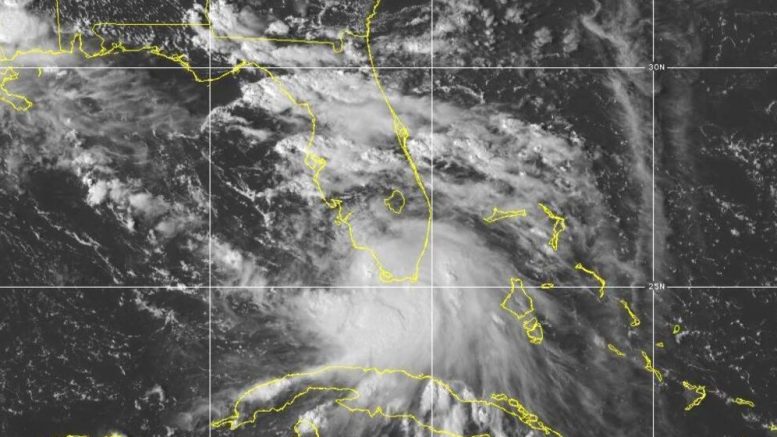
ST. PETERSBURG, Fla. (AP) — Tropical Storm Sally formed Saturday off south Florida amid forecasts it would grow into a hurricane capable of striking the U.S. Gulf Coast in coming days with high winds and a life-threatening storm surge.
The earliest 18th-named storm in an Atlantic tropical season, Sally quickly became better organized within hours of forming and was expected to become a hurricane by late Monday, the National Hurricane Center said. New Orleans and surrounding areas, along with a stretch of the coast from Grand Isle, Louisiana, to the Alabama-Florida line, were placed under a hurricane watch.
Late Saturday, Louisiana Gov. John Bel Edwards declared a state of emergency ahead of the storm, and officials in the New Orleans area issued a mandatory evacuation order for areas outside of levee protection, including Venetian Isles, Lake Catherine, and Irish Bayou. The evacuation order was set to go into effect at 6 p.m. Sunday.
The National Hurricane Center said dangerous storm surge was possible along the northern Gulf Coast starting on Monday and added hurricane conditions could set in there early Tuesday.
The Miami-based hurricane tracking center said Sally spent Saturday afternoon spreading gusty winds and heavy rains around south Florida.
Sally’s maximum sustained winds were clocked at 40 mph (65 kph) with higher gusts.
By late Saturday, Sally was centered about 70 miles (110 kilometers) southwest of Port Charlotte, Florida, and about 425 miles (685 kilometers) east-southeast of the mouth of the Mississippi River. The storm was crawling into the Gulf at a pace of 8 mph (13 kph), heading in a west-northwest direction.
Sally became the earliest 18th-named storm on record in an Atlantic hurricane season, besting Stan when it formed on Oct. 2, 2005, said Colorado State hurricane researcher Phil Klotzbach.
A tropical storm watch has been extended westward from the Okaloosa/Walton County line in Florida to the Alabama-Florida line.
A storm surge watch, meanwhile, was in effect from the mouth of the Mississippi River to the Alabama-Florida line, including Lake Pontchartrain, Lake Maurepas, Lake Borgne in Louisiana — and Mobile Bay in Alabama.
Elsewhere, a strengthening Paulette became a hurricane late Saturday as it bore down on Bermuda, threatening to bring dangerous storm surge, coastal flooding and high winds to the territory in the coming days.
Paulette had maximum sustained winds of 75 mph (120 kph) as of 11 p.m. Saturday, and was about 385 miles (615 kilometers) southeast of Bermuda. Forecasters warned Paulette was expected to become a dangerous hurricane when it nears or crosses over Bermuda on Monday. Life-threatening surf and rip current conditions, as well as heavy rainfall totals, are likely, forecasters said. Residents of the island were urged to rush final storm preparations to a conclusion.
Tropical Storm Rene weakened in recent hours and was reclassified as a tropical depression. It had maximum sustained winds of 35 mph (55 kph) and was about 1,200 miles (1,935 kilometers) east-northeast of the Northern Leeward Islands. Forecasters said Rene wasn’t expected to strengthen and did not pose any threat to land.


